The location of Hồng Hạc City Phú Mỹ Hưng is in Song Lieu Ward (formerly Xuan Lam Commune), Thuan Thanh Town, Bac Ninh Province, at the strategic intersection of the key northern economic triangle. In particular, this is a “golden centre” location at the north-eastern gateway to Hanoi, bringing together geographical, economic and transport factors to become one of the most closely watched satellite urban areas in the north in 2025-2026.
In terms of transport connectivity, Hồng Hạc City is only 25km from central Hanoi, equivalent to a journey of about 35-40 minutes, and is served by several arterial routes such as the Hanoi – Bac Giang expressway, National Highway 5, National Highway 17 and a series of major bridges connecting in multiple directions to the inner city. In addition, a series of infrastructure works now under construction, including Ring Road 4 (just 1km from the project), the road connecting to Gia Binh Airport and the north-south railway, promise to comprehensively upgrade the project’s accessibility in the 2026-2030 period.
In terms of competitive advantage, Hồng Hạc City’s location stands out from ordinary satellite urban areas as the only point bordering three provinces and cities at once — Hanoi, Bac Ninh and Hung Yen — while benefiting simultaneously from both Ring Road 4 and Gia Binh Airport. Next, this article will comprehensively analyse each aspect of the location to help you understand clearly why Hồng Hạc City’s coordinates are rated so highly by property experts.
Where is Hồng Hạc City Phú Mỹ Hưng located?
Hồng Hạc City Phú Mỹ Hưng is located in Song Lieu Ward, Thuan Thanh Town, Bac Ninh Province; it is the first ecological urban area developed by Phú Mỹ Hưng in the northern market, at the strategic intersection of three provinces and cities: Bac Ninh, Hanoi and Hung Yen.
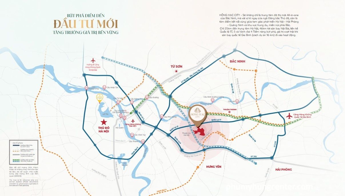
To understand more clearly the project’s specific location, below is a detailed analysis ranging from the administrative place names to the economic region coordinates to which Hồng Hạc City belongs.
In which province and district is Hong Hac City Phu My Hung located?
Hong Hac City is situated in Song Lieu Ward, Thuan Thanh Town, Bac Ninh Province, the official administrative designation under the latest planning scheme following the merger of Xuan Lam Commune and several neighbouring communes into a new administrative unit.

The reason many documents and websites still use the two names “Xuan Lam” and “Song Lieu” interchangeably is that the administrative merger took place during 2024. Specifically, the former name “Xuan Lam Commune, Thuan Thanh District” was changed to “Xuan Lam Ward, Thuan Thanh Town” and subsequently adjusted to “Song Lieu Ward” under Bac Ninh Province’s latest urban upgrading plan. Hong Hac City is in fact spread across 3 wards/communes: Ngu Thai, Song Lieu and Xuan Lam within Thuan Thanh Town.
Administratively, Thuan Thanh is a town within Bac Ninh Province, planned to become one of the key satellite cities of the Red River Delta. Within the strategy to develop Bac Ninh into a centrally governed city, Thuan Thanh serves as the south-western gateway connecting the province, bordering directly on Hanoi and Hung Yen. Furthermore, with a total area of 197.76 hectares spanning multiple wards, Hong Hac City is not merely a property development but in essence a satellite city comparable in scale to a ward-level administrative unit.
At the junction of which provinces is Hong Hac City Phu My Hung located?
Hong Hac City sits at the strategic junction of 3 provinces: Bac Ninh, Hanoi and Hung Yen, while also lying on the Hanoi – Hai Phong – Bac Ninh economic corridor within the key northern economic development triangle of Vietnam.

Specifically, the strategic significance of this three-province border location is reflected in three direct connections:
Connection with Hanoi: Hong Hac City lies right at the north-eastern gateway of the capital, directly bordering Hanoi’s eastern districts such as Gia Lam and Long Bien. This allows residents to reach central Hanoi via multiple routes without depending on a single artery, minimising the risk of traffic congestion.
Connection with Bac Ninh: As the province with the fastest economic growth and FDI attraction in the country, Bac Ninh hosts a concentration of major industrial parks such as Samsung, Canon and VSIP. Its location in the heart of Bac Ninh provides Hong Hac City with a stable, sustainable source of housing demand from the engineers, specialists and high-quality workforce employed at these industrial parks.
Connection with Hung Yen: Hung Yen is a province rising strongly, with new industrial parks and urban areas south of Hanoi. Bordering Hung Yen enables Hong Hac City to expand its sphere of influence southwards, attracting residents from all three directions rather than relying on a single market.
Crucially, this entire area lies within the northern key economic triangle of Hanoi – Hai Phong – Quang Ninh, identified by the Government as one of the country’s leading economic driving regions, with total infrastructure investment of hundreds of thousands of billions of dong during 2021–2030. Bac Ninh in particular has consistently led the nation in FDI attraction for many consecutive years, creating a solid economic foundation for the region’s property development.
How far is Hong Hac City Phu My Hung from central Hanoi, and how long does the journey take?
Hong Hac City is approximately 25km from central Hanoi (Hoan Kiem Lake), equivalent to a 35–40 minute car journey in normal traffic conditions — an ideal distance for a satellite city that is both separate from the congestion and pollution of the urban core and well connected for daily commuting.

Below is a summary table of distances and journey times from Hong Hac City to key destinations in the area, giving you a comprehensive picture of the project’s connectivity:
| Destination | Distance | Travel time | Main route |
| Hoan Kiem Lake, Hanoi | 25 km | 35–40 minutes | Hanoi–Bac Giang Expressway, NH5 |
| Bac Ninh City | 20 km | 25–30 minutes | QL17 |
| Nội Bài Airport | 38 km | 40–50 minutes | NH5, extended Road 5 |
| Gia Binh Airport (2026) | 16 km | 20 minutes | New route under construction |
| Thuan Thanh Industrial Park | 5–7 km | 10–15 minutes | QL17 |
| Old NH5 | 7 km | 10 minutes | Internal cross-axis road |
| Hai Phong City | 70 km | 60–75 minutes | Hanoi–Hai Phong Expressway |
| Dau Pagoda | 1,5 km | 5 minutes | Internal roads |
The table above shows that Hong Hac City enjoys a “just right” distance according to modern satellite city planning criteria: not so far as to lose connectivity with the economic centre, yet not so close that it sacrifices green, tranquil living space and reasonable land costs.
Which is the shortest route from Hong Hac City Phu My Hung to central Hanoi?
The shortest and fastest route from Hong Hac City into central Hanoi is the Hanoi – Bac Giang Expressway combined with extended Road 5, reducing journey time to around 20–25 minutes when traffic is clear.
Specifically, Hong Hac City residents can choose from several routes into central Hanoi depending on their destination and time of travel:
Via Thanh Tri Bridge and National Highway 5: This is the most popular route connecting Hong Hac City with southern Hanoi (Hoang Mai, Hai Ba Trung, Dong Da). From the project, take NH17 to NH5, cross Thanh Tri Bridge onto Ring Road 3 — a journey time of approximately 35–45 minutes.
Via Dong Tru Bridge and extended Road 5: Suitable for residents working in Long Bien, Gia Lam or central Hoan Kiem. From Hong Hac City via the Hanoi – Bac Giang Expressway and across Dong Tru Bridge, the journey takes around 30–40 minutes.
Via Nhat Tan Bridge and Thang Long Bridge: Suitable for residents working in Tay Ho, Cau Giay, Nam Tu Liem or heading to Noi Bai Airport. This route is longer but avoids the congestion at Dong Tru Bridge and the Gia Lam area.
Via Long Bien Bridge and Chuong Duong Bridge: A route connecting with the Old Quarter, Hoan Kiem and Ba Dinh — suitable for residents working in Hanoi’s central core. Moreover, with Hanoi implementing several new bridges across the Red River during 2025–2030, such as Tu Lien Bridge and Ngoc Hoi Bridge, connectivity from Hong Hac City into the city centre will continue to improve significantly.
Is Hong Hac City Phu My Hung near an airport?
Yes, Hong Hac City is close to both of the largest airports in the Hanoi region — Noi Bai Airport (38km away, around 45 minutes) and Gia Binh Airport (16km away, expected to be completed in 2026) — a rare dual advantage that most satellite cities in the region do not enjoy.
Specifically, of the two airports mentioned, Gia Binh Airport is the factor with the greatest long-term impact on Hong Hac City’s property values. Gia Binh Airport is planned in Gia Binh District, Bac Ninh Province, on the same north-eastern development axis as Hong Hac City. Once completed, it will become the capital region’s second international airport, relieving the overloading of Noi Bai and serving the entire north-eastern economic zone.
More importantly, a dedicated connecting road from Hanoi to Gia Binh Airport is being developed in parallel, expected to pass through or directly serve the Thuan Thanh area, creating an entirely new transport corridor for Hong Hac City residents. Once this route is completed, travel time from Hong Hac City to Gia Binh Airport could be just 15–20 minutes — an ideal distance for those who fly frequently for work or leisure.
Which key transport routes does Hong Hac City Phu My Hung connect to?
Hong Hac City connects to 7 key transport routes in two main groups: existing transport (NH5A, NH5B, NH17, the Hanoi – Bac Giang Expressway and the system of major bridges across the Red River) and transport under construction (Ring Road 4, the Hanoi – Gia Binh Airport road and the trans-Vietnam railway).
Let us explore each group of transport routes in detail to understand why experts regard Hong Hac City as benefiting from one of the densest transport infrastructure systems in the north-east Hanoi region.
Which existing roads serve travel from Hong Hac City Phu My Hung?
There are 5 main existing transport arteries connecting Hong Hac City with surrounding economic centres, comprising National Highway 5A, National Highway 5B, National Highway 17, the Hanoi – Bac Giang Expressway and the system of 6 major bridges across the Red River.
Specifically, each existing transport artery plays the following role in Hong Hac City’s connectivity:
National Highway 17 (NH17): The arterial road closest to the project, connecting Hong Hac City with Bac Ninh City to the east and with the Gia Lam area (Hanoi) to the west. Just 600m from the project, NH17 is the “backbone” road serving the daily travel of the vast majority of residents.
National Highway 5A (NH5A): One of the most important economic arteries in northern Vietnam, connecting Hanoi with Hai Phong and Quang Ninh. NH5A opens up extensive commercial connectivity for Hong Hac City residents to seaports and coastal economic zones.
National Highway 5B (Hanoi – Hai Phong Expressway): A modern expressway running directly from Hanoi to Hai Phong, cutting journey time to 45–50 minutes. This is the ideal choice for residents whose work involves Hai Phong port or the industrial parks along the route.
Hanoi – Bac Giang Expressway: The northern expressway connecting Hong Hac City with central Hanoi via extended Road 5 and Dong Tru Bridge. This is the fastest route into the city centre during rush hour when other roads become congested.
System of 6 bridges across the Red River: Thanh Tri, Dong Tru, Long Bien, Tu Lien, Thang Long and Chuong Duong bridges provide 6 different entry points into central Hanoi from 6 directions. This diversity enables Hong Hac City residents to proactively choose the route best suited to their destination and timing, rather than depending on a single bridge.
In addition, the distance from Hong Hac City to National Highway 17 is just 600m and to National Highway 5 only 7km, ensuring the journey from the project’s entrance to a major road never exceeds 10 minutes in any traffic conditions.
Which soon-to-be-completed infrastructure works will benefit residents of Hong Hac City Phu My Hung?
There are 3 major infrastructure projects nearing completion that will directly enhance Hồng Hạc City’s connectivity: Ring Road 4 (expected 2026), the Hanoi – Gia Bình Airport expressway (expected 2026) and the trans-Vietnam railway section running through the northern corridor.
Specifically, the impact of each project on the lives of Hồng Hạc City residents is as follows:
Ring Road 4 – Hanoi Capital Region: This is the project with the greatest and most direct impact on Hồng Hạc City. Located just 1km from the development, once Ring Road 4 is completed, Hồng Hạc City residents will be able to travel around the whole of Hanoi without having to pass through the city centre. This is especially valuable for families whose members work at different locations across the capital region. In addition, Ring Road 4 also opens up direct connections to Nội Bài Airport and the provinces west of Hanoi (Hòa Bình, Phú Thọ) without needing to go through the inner city.
Hanoi – Gia Bình Airport Expressway: The expressway connecting Hanoi with Gia Bình Airport (Bắc Ninh) is being developed along a route that passes through or near the Thuận Thành area. Notably, the project is only 3km from the expressway interchange. When completed in 2026, this route will create an entirely new transport corridor serving residents north-east of Hanoi, while connecting Hồng Hạc City to the capital region’s second international airport in just 15–20 minutes.
The trans-Vietnam railway’s northern corridor section: Under the national master plan, both the North–South high-speed railway and the railway connecting the Hanoi – Hải Phòng – Quảng Ninh region pass through the northern economic corridor where Hồng Hạc City is located. Once these lines are completed, Hồng Hạc City residents will have access to high-speed public transport, extending their reach across the entire northern region without needing a private car.
More importantly, the simultaneous convergence of these 3 major infrastructure projects in 2026 – coinciding with the handover of homes at Hồng Hạc City in December 2026 – creates a rare double opportunity: residents receive their homes precisely when the area’s infrastructure enters a phase of comprehensive upgrading, meaning property values are likely to rise sharply immediately after handover.
What advantages does the location of Hồng Hạc City Phú Mỹ Hưng have over other satellite urban areas north-east of Hanoi?
Hồng Hạc City’s location excels in its multi-provincial connectivity radius: whereas typical satellite urban areas depend on a single province and one main transport axis, Hồng Hạc City benefits from 3 provinces and at least 5 transport corridors simultaneously, delivering superior resilience against congestion and outstanding flexibility of movement.
More specifically, when comparing Hồng Hạc City with other popular satellite urban areas in the same segment north-east of Hanoi, the project’s location stands out in the 2 key respects below.
How does the location of Hồng Hạc City Phú Mỹ Hưng differ from typical satellite urban areas?
Hồng Hạc City wins on multi-directional connectivity as the only urban area in north-east Hanoi to benefit from both Ring Road 4 (1km away) and the Gia Bình Airport route, whereas typical satellite urban areas usually lie close to only one of these two projects.

Most satellite urban areas developed to the east and north-east of Hanoi during 2020–2025 are connected via only one or two main roads, leading to a heavy dependence on a single route. When that route becomes congested, the entire community is affected. By contrast, Hồng Hạc City, with 5 existing transport corridors and 3 major infrastructure projects under construction, allows residents to flexibly choose the optimal route depending on the time of day and their specific destination, minimising travel time.
Does the location of Hồng Hạc City Phú Mỹ Hưng have any notable feng shui or local cultural features?
Hồng Hạc City is situated in the historic Kinh Bắc region, just 1.5km from Bát Tràng pottery village and only 1.5km from Dâu Pagoda (one of the oldest pagodas in Vietnam) – two cultural landmarks with thousands of years of Vietnamese history.
In terms of feng shui, the project sits between three villages with auspicious names signifying growth and longevity, and is surrounded by a 15-hectare regulating lake with a naturally meandering water surface, creating a “water gathering” formation according to traditional feng shui. Furthermore, the east-facing orientation is, in many feng shui schools of thought, considered a favourable direction for “receiving positive energy”, suiting buyers who value this factor when purchasing a long-term home.