Hồng Hạc City is located in Xuân Lâm Commune (Song Liễu Ward after the administrative merger), Thuận Thành District, Bắc Ninh Province, at the strategic junction of 3 provinces and cities—Bắc Ninh, Hanoi and Hưng Yên—and approximately 25km from central Hanoi, equivalent to a 40-minute drive. In particular, property experts regard this location as the “diamond coordinates” of the northeastern area of the capital because it lies within the northern key economic triangle of Hanoi, Hải Phòng and Bắc Ninh. More importantly, no other township project in Bắc Ninh shares borders with 3 provinces and cities simultaneously in the way Hồng Hạc City does.
In terms of transport connectivity, Hồng Hạc City’s location has 5 main regional connectivity advantages, including National Highway 17, National Highway 5A, Ring Road 4 (just 1km away), the route connecting to Gia Bình Airport and the North–South railway line from Lào Cai via Hanoi to Hải Phòng, which passes through Bắc Ninh. In addition, Hồng Hạc City provides rapid connections to dozens of key destinations within a 50km radius, thereby offering maximum convenience for both owner-occupiers and investors seeking to exploit rental opportunities.
Not only is it convenient for transport, but Hồng Hạc City’s location also creates distinctive potential for property appreciation based on 2 micro-niche factors: Gia Bình International Airport, approximately 15km away and currently under development, and the unique administrative advantage of being situated at the intersection of 3 provinces and cities. Furthermore, Bắc Ninh is on a roadmap to become a centrally governed municipality by 2030, a rare administrative upgrade that is expected to drive a wave of property price growth throughout the region.
To gain a clearer understanding of the different layers of information concerning the address, actual distances and location advantages, the article below provides a detailed analysis of each key aspect.
Where Is Hồng Hạc City? Administrative Address and Exact Coordinates
Hồng Hạc City is an eco-urban development located in Xuân Lâm Commune, Thuận Thành District, Bắc Ninh Province, between the three villages of Đa Tiện, Doãn Thượng and Thanh Bình, at a strategically important boundary point between Bắc Ninh, Hanoi and Hưng Yên along the linkage axis of the key economic triangle in northern Vietnam.
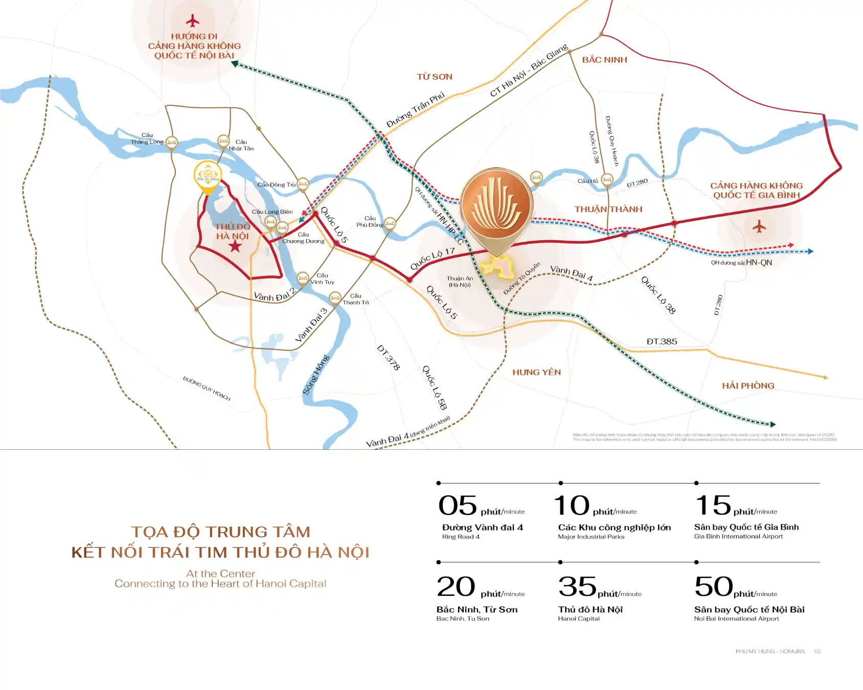
Specifically, Hồng Hạc City’s geographical coordinates place the development in a special location that few new urban areas in northern Vietnam can match: rather than being deep within a provincial area, it lies directly at the gateway where 3 of the most important economic regions converge. To the northwest, it directly borders Gia Lâm District in Hanoi; to the south, it borders Hưng Yên; and to the east lies the heart of Bắc Ninh Province. As a result, residents and investors can quickly access the labour markets, services and infrastructure of all 3 economic regions, rather than being restricted to a single locality.
It is particularly important to note the administrative place name: Hồng Hạc City was originally located in Xuân Lâm Commune, but following the administrative merger process in Bắc Ninh Province during 2024-2025, the development’s address was updated to Song Liễu Ward, Thuận Thành Town, Bắc Ninh Province. This change affects only the administrative name and does not alter the actual location or the project’s legal status.
Below is a detailed analysis of the address and actual distances from the most common starting points.
Which Province and District Is Hồng Hạc City In, and Where Is It Located Within Northern Vietnam’s Economic Region?
Hồng Hạc City is in Bắc Ninh, Thuận Thành District, in Xuân Lâm Commune (Song Liễu Ward following the merger), at the intersection of the Hanoi–Hai Phong–Bắc Ninh economic triangle, recognised as northern Vietnam’s key economic region and the area attracting the country’s greatest infrastructure investment and FDI.
Specifically, within the planning framework for northern Vietnam’s economic region, Hồng Hạc City is positioned as follows:
- West: Directly borders Gia Lâm District, Hanoi – approximately 10km from Bát Tràng pottery village and approximately 20km from Văn Giang District (Hưng Yên) via Thanh Trì Bridge
- East: Located on the route leading to Bắc Ninh city centre, where the Samsung and LG industrial parks and hundreds of Japanese and South Korean FDI enterprises are concentrated
- South: Connected to Hưng Yên via the former National Highway 5 and National Highway 38, extending the economic sphere of influence towards the south of the Red River Delta
- North: Connected to Bắc Ninh city and the Tiên Du and Yên Phong industrial parks via National Highway 17
More importantly, Bắc Ninh has led the country in attracting foreign direct investment (FDI) for many consecutive years, with dozens of industrial parks and hundreds of thousands of foreign experts and engineers living and working there. Therefore, demand for high-quality housing serving this highly skilled workforce provides a sustainable demand base for property at Hồng Hạc City, making it entirely different from typical satellite urban markets.
How Long Does It Take to Travel from Hanoi to Hồng Hạc City, and Which Route Should You Take?
There are 3 most common routes from Hanoi to Hồng Hạc City, depending on the starting point: via National Highway 17 from Gia Lâm (the fastest, 25km – 35 minutes), via Chương Dương Bridge and the former National Highway 5A (35km – 45 minutes), and via Ring Road 3 to National Highway 38 (40km – 50 minutes).
Specifically, below are 3 actual routes from the most common starting points in Hanoi (the table describes the 3 routes from Hanoi to Hồng Hạc City by distance, travel time and starting point, helping readers choose the most suitable route):
| Route | Starting point | Distance | Journey time | Road |
| Route 1 (fastest) | Gia Lâm, Long Biên | ~25km | ~35 minutes | Thanh Trì Bridge → National Highway 17 → Hồng Hạc City |
| Route 2 (from the city centre) | Hoàn Kiếm, Hai Bà Trưng | ~30km | ~40 minutes | Chương Dương Bridge → National Highway 5A → Turn onto National Highway 17 |
| Route 3 (from the west) | Cầu Giấy, Đống Đa | ~40km | ~50 minutes | Ring Road 3 → Thanh Trì Bridge → National Highway 17 |
The route from Gia Lâm and Long Biên via National Highway 17 is particularly important: it is currently the fastest and most convenient route, taking only around 35 minutes in normal traffic conditions. However, when Ring Road 4 is completed (expected in 2027-2028), journey times from all points in Hanoi to Hồng Hạc City will be significantly reduced, particularly from western Hanoi (Hà Đông and Thanh Xuân) and the north (Đông Anh and Mê Linh), which currently lack a convenient direct route.
In addition, buyers and investors should note that the Hồng Hạc City Sales Gallery is located in Song Liễu Ward, Bắc Ninh Province, and is open from 8:00 to 17:00 every day of the week to welcome visitors to the development.
What Are the Transport Connectivity Advantages of Hồng Hạc City’s Location?
Hồng Hạc City’s location has 5 main transport connectivity advantages, based on 5 criteria: existing national highways (National Highways 17 and 5A), infrastructure currently under development (Ring Road 4 and Gia Bình Airport), inter-regional railways, and air connectivity (Nội Bài and Gia Bình).
Specifically, it is no coincidence that Phu My Hung Development Corporation selected Thuận Thành as the location for a development on the scale of Hồng Hạc City. This location was chosen following serious market research conducted to Nomura Real Estate Vietnam’s Japanese standards, thereby ensuring the development’s optimal position within a 30km radius of central Hanoi, with a 200ha land bank. Below is an analysis of each specific transport connectivity advantage.
Which Major Transport Routes Is Hồng Hạc City Connected To?
Hồng Hạc City is directly connected to 5 major transport routes across 3 groups: existing national highways (National Highways 17, 5A and 38), infrastructure currently under development (Ring Road 4 and the Gia Bình Airport route), and inter-regional railways (the Lào Cai–Hanoi–Hai Phong line passing through Bắc Ninh).
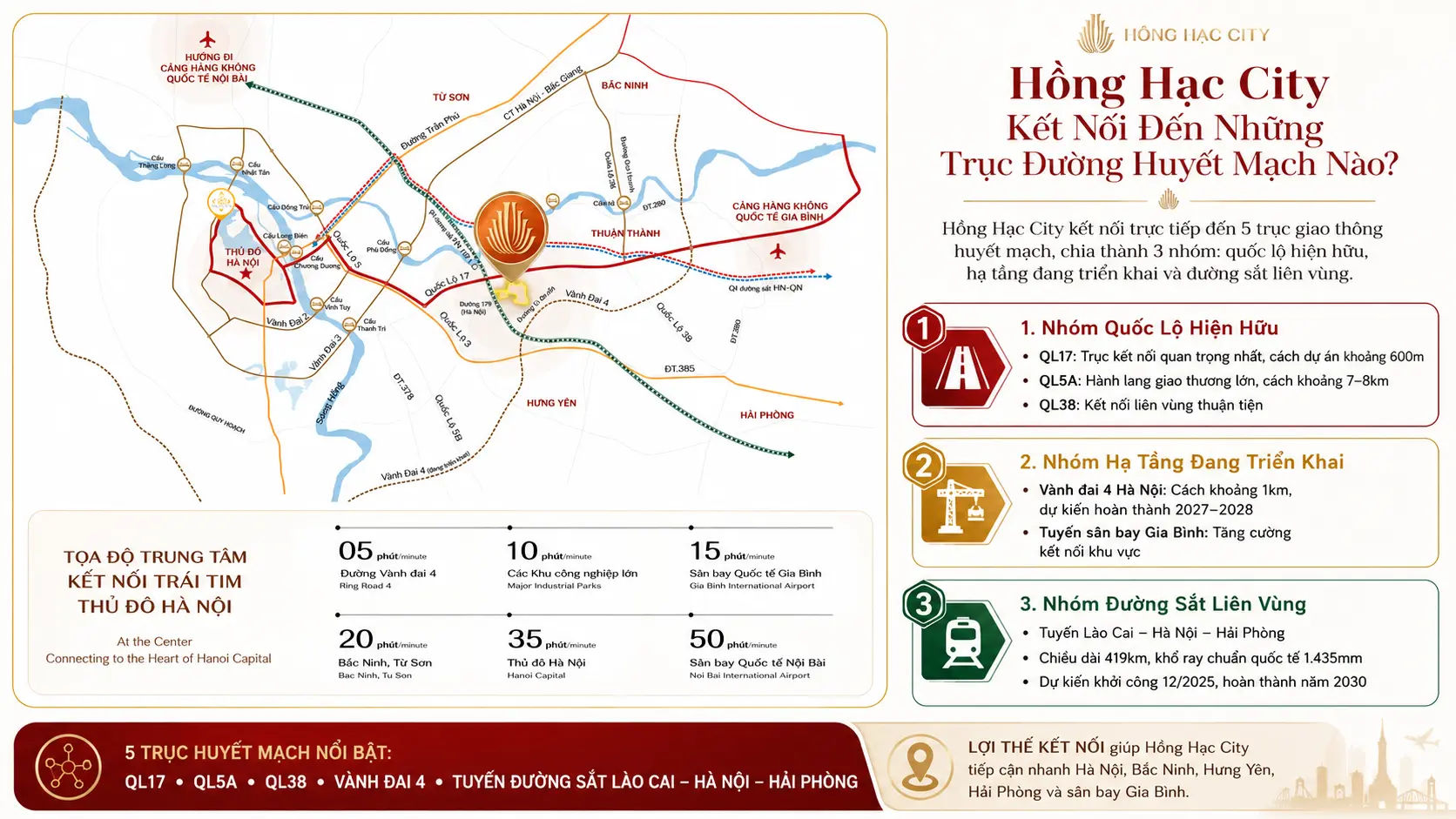
The specific transport routes are as follows:
National Highway 17 is the most important and nearest connection to Hồng Hạc City, approximately 600m from the development. This route runs directly from Gia Lâm (Hanoi) to Thuận Thành, Bắc Ninh, allowing direct travel without passing through the city centre. In particular, National Highway 17 is scheduled to be upgraded and widened to 4-6 lanes during 2025-2030, thereby increasing traffic capacity and further reducing journey times.
National Highway 5A is northern Vietnam’s largest commercial corridor, running from Hanoi through Hưng Yên and Hải Dương to Hai Phong and Quảng Ninh. Hồng Hạc City is approximately 7-8km from National Highway 5A and can be accessed quickly via connecting cross routes. This is the region’s most important freight and passenger transport corridor, thereby creating commercial opportunities for Hồng Hạc City’s shophouses to serve demand throughout the economic corridor along National Highway 5A.
Hanoi Ring Road 4 is the most important infrastructure project for Hồng Hạc City’s long-term value. The project is currently under construction and is expected to be completed in 2027-2028. In particular, Hồng Hạc City is only approximately 1km from Ring Road 4, making it one of the private property developments closest to Ring Road 4 in eastern Hanoi. Once completed, Ring Road 4 will connect all of Hanoi’s satellite provinces and cities (Hưng Yên, Bắc Ninh, Bắc Giang and Hà Nam) in a continuous circulation loop, thereby eliminating the traditional traffic bottleneck when travelling into central Hanoi.
The Lào Cai–Hanoi–Hai Phong railway line is under development, with a length of 419km and an international standard track gauge of 1,435mm. Construction is expected to begin in December 2025 and be completed in 2030. The line will pass through Bắc Ninh, thereby creating a direct rail connection from Hồng Hạc City to central Hanoi and Hai Phong Port, improving convenience for residents and significantly enhancing logistics throughout the area.
What Are the Distances from Hồng Hạc City to Key Destinations?
Hồng Hạc City has 8 important reference distances divided into 3 groups: air transport (Nội Bài and Gia Bình), urban and economic centres (Hanoi, Bắc Ninh and Hai Phong), and cultural and amenity destinations (Dâu Pagoda, Bát Tràng and Ring Road 4).
Below is a detailed distance table covering the 8 most important destinations from Hồng Hạc City (the table describes the distances and estimated travel times from Hồng Hạc City to key destinations, helping buyers and investors quickly assess the development’s regional connectivity):
| Destination | Distance | Estimated travel time | Transport |
| Central Hanoi | ~25km | ~40 minutes | By car via National Highway 17 |
| Nội Bài Airport | ~38-46km | ~60-70 minutes | By car via National Highway 17 + National Highway 1B |
| Gia Bình Airport (under construction) | ~15km | ~20-25 minutes | By car via the connecting road |
| Bắc Ninh City | ~15km | ~20 minutes | By car via National Highway 17 |
| Hai Phong City | ~70km | ~90 minutes | By car via National Highway 5A |
| Ring Road 4 | ~1km | ~5 minutes | By car |
| Dâu Pagoda (national heritage site) | ~1,5km | ~5 minutes | Cars/motorbikes |
| Bát Tràng Ceramic Village | ~10km | ~15 minutes | By car via National Highway 17 |
The most notable point in the distance table above is the distance to Gia Bình Airport, at just ~15km. This figure is highly advantageous for investors, as new international airports always create a wave of property price growth within a 20–30km radius. In addition, the distance of just 1.5km to Dâu Pagoda and the historic sites of the ancient Luy Lâu region represents a rare cultural advantage, creating feng shui and historical value that no new development can recreate or add after its location has been selected.
Furthermore, the distance of just 1km to Ring Road 4 is particularly important for long-term liquidity: once this route is completed, Hồng Hạc City will sit directly on a new interprovincial transport axis, thereby transforming the development from “a destination you need to find your way into” into “a natural stop along the capital’s eastern urban corridor”.
How Does Hồng Hạc City’s Location Affect the Property’s Potential for Price Growth?
Hồng Hạc City’s location affects the property’s potential for price growth in 2 ways: Gia Bình Airport (~15km away) will drive demand from airport workers and the aviation services ecosystem, while its position bordering Bắc Ninh, Hà Nội and Hưng Yên will generate diverse demand from 3 local markets simultaneously, rather than depending on just one province.
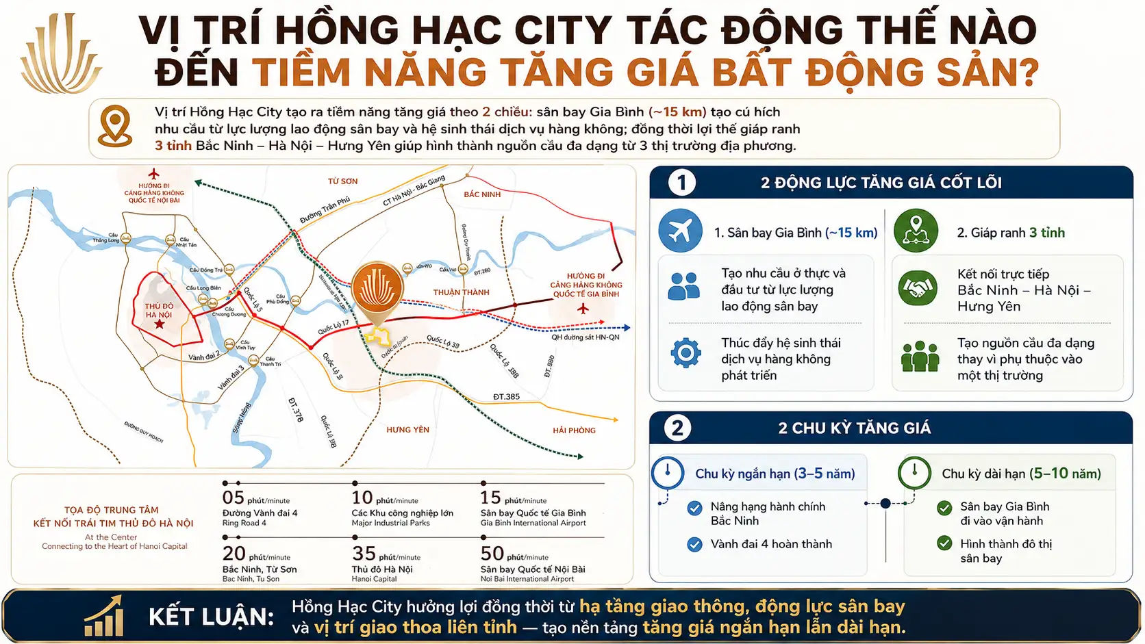
Specifically, these 2 distinctive micro-level factors create potential for price growth over 2 different cycles: a short-term cycle (3–5 years) driven by Bắc Ninh’s administrative reclassification and the completion of Ring Road 4, and a long-term cycle (5–10 years) driven by the opening of Gia Bình Airport and the formation of an airport city. Below is a detailed analysis of each factor.
How Far Is Gia Bình Airport from Hồng Hạc City, and How Will It Affect Property Prices?
Gia Bình Airport is approximately 15km from Hồng Hạc City as the crow flies and is a nationally important aviation infrastructure project. Once operational, it will create substantial demand for housing and services within a 20–30km radius, directly benefiting property values in Thuận Thành, Bắc Ninh. A practical lesson from the area around Nội Bài Airport is that land prices in Đông Anh, Sóc Sơn and the districts neighbouring the airport increased 2 to 4 times in the 10 years after the airport expanded its capacity (2010–2020). Similarly, Hồng Hạc City lies within the ideal radius to benefit from Gia Bình Airport: it is close enough for quick access (20–25 minutes) without being affected by aviation noise, thereby offering the best combination of infrastructure access and quality of living environment.
What Investment Advantages Does Hồng Hạc City’s Location on the Borders of 3 Provinces Create That Other Developments Do Not Have?
Hồng Hạc City’s location on the borders of Bắc Ninh, Hà Nội and Hưng Yên creates 3 exclusive investment advantages that no other urban development in Bắc Ninh has: simultaneous demand from 3 local markets, benefits from the infrastructure plans of all 3 provinces and cities, and cultural and feng shui value from the ancient Luy Lâu region along the Đuống River. Specifically, in terms of market advantages, buyers from Hà Nội, Bắc Ninh and Hưng Yên all regard Hồng Hạc City as “close to home” according to their own geographical perspective, thereby creating a diverse residential community and a more liquid secondary market than a development serving only one population area. In addition, the feng shui qualities of its setting beside the Đuống River and in the ancient Luy Lâu region hold strong emotional appeal for mid-to-upper-market owner-occupiers, a customer group that values both material and spiritual qualities when choosing a long-term home.