Hong Hac City is 25km from central Hanoi, equivalent to a 40-minute drive via National Highway 17. It is located in Xuan Lam Commune, Thuan Thanh District, Bac Ninh Province. The project directly borders Gia Lam District (Hanoi), is adjacent to the famous Bat Trang pottery village and lies at the westernmost point of Bac Ninh Province. More importantly, this is among the shortest convenient driving distances to a large-scale ecological urban area currently available in northern Vietnam.
There are 3 main routes from Hong Hac City to Hanoi: National Highway 17 (600m from the project), the former National Highway 5 (8km away) and Ring Road 4, currently under construction (3km away). In addition, besides connecting to Hanoi, residents can easily reach Noi Bai International Airport (46km), Gia Binh Airport (5km), Bac Ninh City (20km) and Hai Phong Port (70km). Furthermore, this entire transport network positions Hong Hac City as one of the urban areas with the strongest regional connectivity in the North.
In particular, Hong Hac City lies within the “key economic triangle” of Hanoi – Hai Phong – Bac Ninh, a strategic intersection of the North’s three largest economic cities and provinces. Below is all the information on Hong Hac City’s distances, routes and locational advantages, giving you the most comprehensive overview before making a decision.
How far is Hong Hac City from central Hanoi?
Hong Hac City is 25km from central Hanoi, equivalent to a 40-minute drive via National Highway 17. It is located in Xuan Lam Commune, Thuan Thanh District, Bac Ninh Province, at the westernmost point of Bac Ninh Province, directly bordering Gia Lam District (Hanoi).
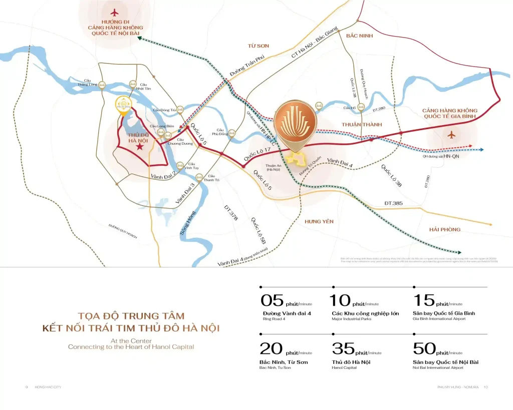
More specifically, Hong Hac City New Urban Area extends across 3 communes—Xuan Lam, Ngu Thai and Song Lieu—in Thuan Thanh District, Bac Ninh Province. It directly borders Bac Ninh and Hanoi, immediately adjacent to Gia Lam District, creating a distinctive geographical advantage possessed by very few satellite urban areas in northern Vietnam.
Hong Hac City lies in the border area between 3 provinces and cities: Bac Ninh, Hanoi and Hung Yen, along the Hanoi – Hai Phong – Bac Ninh economic corridor. This location not only ensures a short distance to central Hanoi, but also enables flexible travel to numerous key economic provinces and cities throughout the Red River Delta.
Administratively, the project is located at the centre of 3 villages: Da Tien, Doan Thuong and Thanh Binh in Xuan Lam Commune. This area has long been known as fertile land with a longstanding craft-village tradition, situated on the ancient trading route connecting Hanoi with the Kinh Bac region to the north.
In particular, Hong Hac City is adjacent to the famous Bat Trang pottery village, a longstanding cultural, tourism and commercial symbol of Hanoi. Its proximity to Bat Trang not only brings cultural value to the urban area, but also further strengthens its practical geographical connection with Hanoi to the south-east, confirming that the boundary between the project and Hanoi is almost administrative rather than genuinely geographical.
Which routes can be used to travel from Hong Hac City to Hanoi?
There are 3 main routes from Hong Hac City to Hanoi, assessed by distance and travel time: National Highway 17 (the nearest route, 600m from the project), the former National Highway 5 (8km away) and Ring Road 4, currently under construction (3km away).
Below is a detailed analysis of each route connecting Hong Hac City with Hanoi:
What are the advantages of National Highway 17 from Hong Hac City to Hanoi?
National Highway 17 is the nearest and most convenient route from Hong Hac City to Hanoi, with the project entrance just 600m away, allowing residents to access this major artery immediately without travelling through numerous internal roads and adding extra time.
Specifically, the journey from Hong Hac City to Hanoi via National Highway 17 is as follows:
- Depart from the project entrance to National Highway 17 (600m, approximately 2 to 3 minutes)
- Travel westwards along National Highway 17 through Gia Lam District (Hanoi)
- Enter the city centre via Chuong Duong Bridge or Thanh Tri Bridge, depending on the destination
- Total journey time: approximately 35 to 40 minutes in normal traffic conditions
Furthermore, National Highway 17 also connects directly to several other important destinations along the route, including Pho Noi Industrial Park (Hung Yen), Tien Son Industrial Park (Bac Ninh) and National Highway 5 to Hai Phong. This is why the route serves not only residents’ daily travel needs, but also acts as a vital freight-trading artery for the entire northern key economic region.
Will Ring Road 4 shorten the journey from Hong Hac City to Hanoi?
Yes, Ring Road 4 will significantly shorten the journey from Hong Hac City to Hanoi. The route is just 3km from the project and, once completed, will connect directly to western Hanoi, Hung Yen and Bac Ninh City without requiring travel through inner-city junctions that frequently experience peak-hour congestion.
Specifically, Ring Road 4 is a strategic ring-road project for the Hanoi Capital Region, with a total length of approximately 112km, passing through Hanoi, Hung Yen and Bac Ninh. It will be one of the most important regional transport routes in northern Vietnam over the next decade.
Once Ring Road 4 is completed, Hong Hac City residents will benefit directly in 4 ways:
- Connection to western Hanoi: quick access to Ha Dong, Nam Tu Liem and Hoai Duc without travelling through the inner city
- Connection to Hung Yen: reduced travel distances to major industrial parks such as Pho Noi and Tan Quang
- Connection to Bac Ninh City: the shortest route linking the two economic centres of Bac Ninh Province
- Reduced travel time: the journey to central Hanoi is expected to take only 25 to 30 minutes once Ring Road 4 opens to traffic
More importantly, in addition to National Highway 17 and Ring Road 4, Hong Hac City residents will also have the option of using the former National Highway 5 (8km away), creating an unusually flexible multi-route transport network compared with most other satellite urban areas in northern Vietnam today.
Is Hong Hac City really close to central Hanoi?
Yes, Hong Hac City is genuinely close to central Hanoi for 3 clear reasons: 25km is considerably shorter than many inner-city journeys during congestion, it directly borders Gia Lam District (Hanoi) and National Highway 17 is just 600m from the project entrance, allowing residents to reach the main route immediately.
More specifically, practical comparisons show that the 25km distance from Hong Hac City to Hanoi is not as far as initially feared:
The first reason is that travelling within Hanoi during peak hours often takes 45 to 60 minutes just to get from Hoang Mai District to Dong Da District (only 7 to 10km within the city). By contrast, travelling from Hong Hac City to Hanoi via National Highway 17 takes only 40 minutes despite the 25km distance. This shows that the journey from Hong Hac City to Hanoi is not actually less convenient than travelling between inner-city districts.
The second reason, Hồng Hạc City directly borders Gia Lâm District (Hanoi). Geographically, there is virtually no distinction between the boundary of the urban area and Hanoi’s territory. Residents can travel from the development into Hanoi in just a few minutes, gaining immediate access to the amenities of Long Biên and Gia Lâm without having to travel into the city centre.
The third reason, with National Highway 17 just 600m from the development entrance, Hồng Hạc City residents do not have to spend additional time travelling through the development before reaching the main road. This differs from many other satellite urban areas in northern Vietnam, where residents must travel 2 to 5km along internal roads before reaching a national highway or expressway.
In particular, once Ring Road 4 is completed and the Gia Bình–Hanoi Expressway becomes operational, the journey from Hồng Hạc City to central Hanoi is expected to be reduced to just 25 to 30 minutes, making this one of the satellite urban areas with the fastest connections to Hanoi in the northern region.
How many kilometres is Hồng Hạc City from other key destinations?
From Hồng Hạc City to 6 key destinations based on regional connectivity: central Hanoi (25km), Nội Bài Airport (46km), Gia Bình Airport (5km), Bắc Ninh City (20km), Hải Phòng (70km) and Hưng Yên (directly adjacent).
For a comprehensive illustration, the table below summarises the distances and travel times from Hồng Hạc City to the most important destinations in the Northern Key Economic Region:
| Destination | Distance | Estimated travel time |
| Central Hanoi | 25km | Approximately 40 minutes |
| Bắc Ninh City | 20km | Approximately 30 minutes |
| Nội Bài Airport | 46km | Approximately 45 to 50 minutes |
| Gia Bình Airport (under development) | 5km | Approximately 10 minutes |
| Hải Phòng Port | 70km | Approximately 80 to 90 minutes |
| Hưng Yên | Directly adjacent | A few minutes |
| National Highway 17 | 600m | 2 to 3 minutes |
| Old National Highway 5 | 8km | Approximately 15 minutes |
| Ring Road 4 (under construction) | 3km | 5 to 8 minutes |
Below is a detailed analysis of the distance to each destination:
How far is Hồng Hạc City from Nội Bài Airport and Gia Bình Airport?
Hồng Hạc City is 40km from Nội Bài International Airport (approximately 45 to 50 minutes) and just 15km from Gia Bình Airport (approximately 10 minutes), creating a rare dual aviation advantage for an ecological urban development in northern Vietnam.

Specifically, these two airports offer entirely different connectivity benefits:
For Nội Bài International Airport (46km): This is the largest international aviation gateway in northern Vietnam, serving hundreds of domestic and international flights every day. At a distance of 46km, Hồng Hạc City residents need to leave just 60 minutes in advance to arrive at the airport on time, making it highly convenient for business trips and domestic and international travel.
For Gia Bình Airport (5km): This is the capital region’s second international airport project, currently under development in Gia Bình District, Bắc Ninh Province. At just 5km away, Hồng Hạc City is ideally positioned to benefit directly from the entire wave of economic and infrastructure development once the airport becomes operational. In particular, the arrival of Gia Bình Airport is expected to have a major impact on property values throughout the Thuận Thành area, with Hồng Hạc City being the earliest and most direct beneficiary thanks to its closest proximity.
How many kilometres is Hồng Hạc City from Bắc Ninh City, Hải Phòng and Hưng Yên?
Hồng Hạc City is 20km from Bắc Ninh City (approximately 30 minutes), 70km from Hải Phòng (approximately 80 to 90 minutes) and directly adjacent to Hưng Yên, creating a powerful and comprehensive trio of regional economic connections.
Specifically, the practical significance of each connection for residents and investors is as follows:
For Bắc Ninh City (20km): Bắc Ninh is the province’s administrative, commercial and industrial centre, as well as the locality with the highest average per-capita income in Vietnam, thanks to the presence of Samsung, Canon, LG and hundreds of leading global FDI enterprises. The 20km distance enables Hồng Hạc City residents to travel easily to this economic centre every day.
For Hải Phòng Port (70km): Hải Phòng is the largest container seaport in northern Vietnam and the import and export gateway for the entire Red River Delta. At 70km away, business owners and investors at Hồng Hạc City can reach Hải Phòng Port within 1.5 hours, making import-export and logistics activities convenient.
For Hưng Yên (directly adjacent): Hồng Hạc City is located at the boundary between Bắc Ninh and Hưng Yên, allowing residents to reach Hưng Yên’s major industrial parks, such as Phố Nối and Tân Quang, within a few minutes, opening up significant potential for labour and business connectivity.
What advantages does Hồng Hạc City’s position within the Hanoi–Hải Phòng–Bắc Ninh economic triangle offer?
Hồng Hạc City’s position within the Hanoi–Hải Phòng–Bắc Ninh economic triangle offers investors 3 core advantages: anticipating future infrastructure developments (the Gia Bình Expressway, Gia Bình Airport and Ring Road 4), being located in Vietnam’s largest FDI hub, and offering considerably more reasonable prices than projects at a similar distance in Gia Lâm (Hanoi).
How will the Gia Bình–Hanoi Expressway and Tứ Liên Bridge affect the value of Hồng Hạc City?
The 10-lane Gia Bình–Hanoi Expressway, connected via Tứ Liên Bridge directly to the Hồ Tây area, will reduce the journey from Hồng Hạc City to central Hanoi to under 30 minutes once completed, while also creating a wave of property price growth throughout the Thuận Thành area. Hồng Hạc City is the project closest to the starting point of this expressway, placing it in a position to benefit directly and earliest when the route becomes operational, with expected property price growth across the area estimated at 30 to 50% over the next 5 years.

How does Hồng Hạc City’s position compare with projects in Gia Lâm at a similar distance from Hanoi?
Hồng Hạc City is the same distance from Hanoi as projects in Gia Lâm (25km), but its selling prices are 1.5 to 2 times lower than comparable projects in Gia Lâm due to the “Hanoi household registration” factor. Specifically, while villas in Gia Lâm currently cost from VND 60 to 100 billion for comparable floor areas, Hồng Hạc City villas cost only from VND 23 to 60 billion, with the same Phú Mỹ Hưng standards, an ecological setting with 70% greenery, and separate pink-book ownership with long-term tenure. This is a clear price differential as Bắc Ninh is becoming the province with the highest average per-capita income in Vietnam, reinforcing Hồng Hạc City’s long-term investment value.